The Öræfajökull jökulhlaups
of 1362 and 1727


by Thomas XX

The Öræfajökull jökulhlaups of 1362 and 1727

The devastating 1362 eruption of Öræfajökull saw approximately 10km3 of rhyolitic ash emitted from the volcano concentrated towards east-south-east (Selbekk and Trønnes, 2007). The sediment-ridden jökulhlaup outbursts become deposited on the lowland regions. The subsequent growth of lichens upon these deposits provides opportunities for lichenometric dating. In other words, the age of the deposits can be determined using the size of lichens. 

Mobirise

Iceland ice cave

Geological Setting

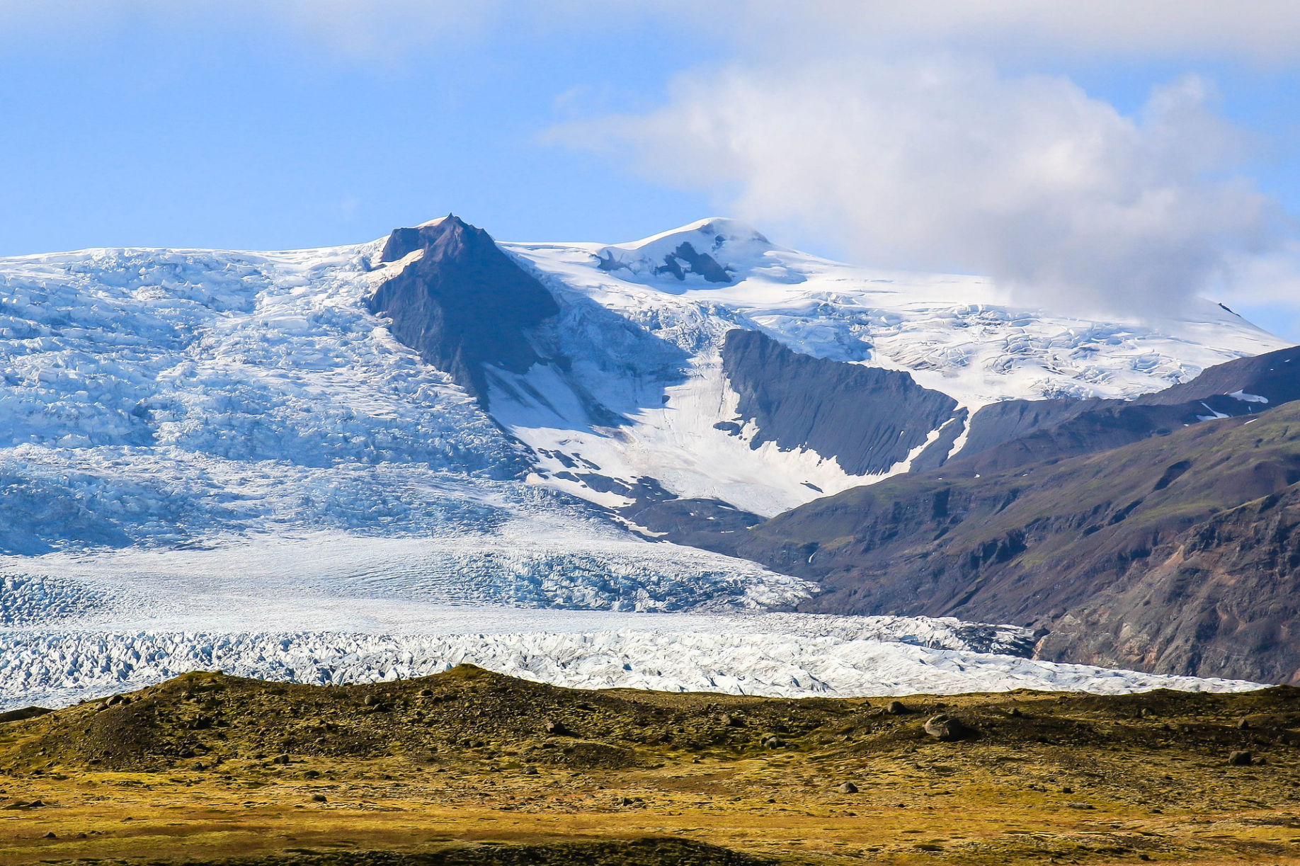
Öræfajökull is an ice-capped stratovolcano which lies on the southeast coast of Iceland on the southern tip of the Vatnajökull ice cap (Stevenson et al., 2006). Although seismically quiet with small-magnitude eruptions (Pagli et al., 2007), the volcano is positioned within the moderately-active volcanic system joined with Esjufjöll and Snæfell (Larsen et al., 2015). Although eruptions of Öræfajökull have occurred during both glacials and interglacials (Prestvik, 1980), it is the interaction between mafic and silicic magma and ice that results in jökulhlaup events.

What are jökulhlaups?

Large scale glacial outburst floods are known as jökulhlaups. Volcanically-induced jökulhlaups occur when subglacial volcanic activity interacts with the overlying ice sheet, resulting in rapid and often large-scale glacial meltwater drainage events. Literally, it translates as ‘glacier burst’ in Icelandic; the country where these are events are most common (Gudmundsson, 2015). These events are characterised by high-discharge of meltwater with readily available sediment which are deposited upon the lowlands.

The Öræfajökull jökulhlaups of 1362 and 1727

The devastating 1362 eruption of Öræfajökull saw approximately 10km3 of rhyolitic ash emitted from the volcano concentrated towards east-south-east (Selbekk and Trønnes, 2007). Details of the 1362 eruption are provided in great detail by Thararinsson (1958) in the novel The Öræfajökull eruption of 1362. The eruption was temporally very short-lived, lasting some 1-2 days, however, it was one of the most potent eruptions in Icelandic volcanic history with over 10km^3 of tephra discharged from the eruption. Its potency is highlighted by the spatial extent of the eruption as tephra samples from the eruption have been identified in ice cores from Greenland (72°35’N, 38°28’W; 3210m) (Palais et al. 1991) as well as peat-bog cores from Scandinavian regions (Pilcher et al. 2005). The eruption induced extensive jökulhlaups where the discharge may have exceeded 1x10⁵ m3/s (Thorarinsson, 1958) at its peak; entraining and depositing sediment on the sandur. Lowland areas were inundated with glacial meltwater and dead ice as farm infrastructure was washed away. An account of the glacial flood is given from Church annals and translated in Thorarinsson’s (1958, p. 26) paper, which reads: “At the same time there was a glacier burst from Knappafellsjökull [now known as Öræfajökull] into the sea carrying such quantities of rocks, gravel and mud as to form a sandur plain where there had previously been thirty fathoms [~55 m] of water.” Due to the sheer ferocity of the glacial outburst, conduits were not able to adjust to the flow and basal sliding incurred as basal friction reduced.

Mobirise

The Mountain

Just how much sediment became deposited upon the lowland? 

Determining the total sediment load of the jökulhlaup events is challenging due to the spatial extent of sediment deposition and the complexities of attributing sediment to each individual event. It is also challenging due to the washing away and overriding of sediments by the later 1727 jökulhlaup. However, sedimentary deposits in the order of metres have been identified some 4km west of Falljökull weighing over 500 tonnes (Roberts and Gudmundsson, 2015). Deposits have also been classified in the regions of Forarjökull, Grasjökull, and Miðjökull. Explorers described the post 1727 jökulhlaup landscape as one ridden with debris spanning some 3km wide and 13km long (Roberts and Gudmundsson, 2015). Similarly, to 1362, deciphering the extent and quantity of the sediment load is challenging as the region has been reworked by glacial advance and retreat.

Although smaller than the 1362 eruption, the explosive benmoreitic 1727 Öræfajökull eruption emitted less than 0.2km³ of tephra (Thorarinsson, 1958). Similarly, to 1362, large masses of dead ice were carried through the lowlands and destroyed pastures, while “white and porous pumice” (Reverand E. Hálfdánarson, n.d.) covered south east Iceland. Jökulhlaups from this eruption claimed the lives of three people and destroyed entire villages, as stated in Thorarinsson’s (1958) account.

Mobirise

Lichen

Opportunities for Lichenometric Analysis

The sediment-ridden jökulhlaup outbursts become deposited on the lowland regions. The subsequent growth of lichens upon these deposits provides opportunities for lichenometric dating. In other words, the age of the deposits can be determined using the size of lichens. If the time between the point of exposure of the deposit and when lichens begin colonising is known, along with their species-specific growth characteristics, it is possible to determine the age of the deposits (Innes, 1985). For example, for the Öræfajökull eruptions of 1362 and 1727, populations of ‘Rhizocarpon geographicum’, which have since colonised the deposits, illuminate the age of the deposits and the spatial extent of sediment transport. Interestingly, however, lichen analyses of the Öræfajökull jökulhlaups show the 1362 deposits have been overridden by the 1727 deposits. Without analysis of R. geographicum, it may become challenging to decipher the sedimentary deposits of the events which contrasted in magnitude.

Mobirise

A glacier in Canada

Why is this of importance to glaciologists?

Although glaciology is largely concerned with the study of ice, the interaction between volcanoes and ice induces jökulhlaup events that shape entire landscapes. It is also widely speculated that deglaciation through climate change may increase the occurrence of jökulhlaup events (Carrivick, 2011). This is due to more frequent volcanic eruptions through the gradual release of stress upon volcanoes as the ice melts (Carrivick, 2011). Such events have implications beyond the field of study because they affect the way in which humans interact with the environment; whether that be land-management practices or emergency responses to outburst events.

Share this Page!

Mobirise
Thomas XX
PhD student

My name is Thomas and I have just finished my final year at the University of Liverpool, England. Although my degree was in Geography, elective modules allowed me to follow my glaciological interests and pursue the field in great detail; plus I was able to visit some extraordinary places! My passion for glaciology began after standing face-to-face with a calving margin and realising the sheer power of glaciers and their ability to calve, mould and shape landscapes of the past, present and future. I hope you enjoyed reading my first blog entry!

References

  • Carrivick, J.L., (2011). Jökulhlaups: geological importance, deglacial association and hazard management. Geology Today 27 (4), 133-140.
  • Gudmundsson, M.T., (2015). Hazards from lahars and Jökulhlaups. In The Encyclopaedia of Volcanoes (pp. 971-984). Academic Press.
  • Innes, J.L., 1985. Lichenometry. Progress in physical geography, 9(2), pp.187-254.
  • Larsen, Gudrún, Magnús T. Gudmundsson, Kristín Vogfjörð, Evgenia Ilyinskaya, Björn Oddsson, Emmanuel Pagneux. (2015). The Öræfajökull volcanic system. In: Ilyinskaya, Larsen and Gudmundsson (eds.): Catalogue of Icelandic Volcanoes. IMO, UI, CPD-NCIP.
  • Pagli, C., Sigmundsson, F., Lund, B., Sturkell, E., Geirsson, H., Einarsson, P., Árnadóttir, T. and Hreinsdóttir, S., (2007). Glacio‐isostatic deformation around the Vatnajökull ice cap, Iceland, induced by recent climate warming: GPS observations and finite element modeling. Journal of Geophysical Research: Solid Earth, 112(B8).
  • Prestvik, T., (1980). Petrology of hybrid intermediate and silicic rocks from Öræfajökull, southeast Iceland. Geologiska Föreningens i Stockholm Förhandlingar 101, 299–307.
  • Roberts, M.J. and Gudmundsson, M.T., (2015). II. ÖRÆFAJÖKULL VOLCANO: GEOLOGY AND HISTORICAL FLOODS. Volcanogenic floods in Iceland, p.17.
  • Selbekk, R.S. and Trønnes, R.G., (2007). The 1362 AD Öræfajökull eruption, Iceland: Petrology and geochemistry of large-volume homogeneous rhyolite. Journal of Volcanology and Geothermal Research, 160(1-2), pp.42-58.
  • Stevenson, J.A., McGarvie, D.W., Smellie, J.L. and Gilbert, J.S., (2006). Subglacial and ice-contact volcanism at the Öræfajökull stratovolcano, Iceland. Bulletin of volcanology, 68(7-8), pp.737-752.
  • Þórarinsson, S., (1958). The Öræfajökull eruption of 1362.

Made with ‌

Free Web Page Building Software